IoT-Integrated Autonomous Vehicles: A Comprehensive Study of Sensing, Processing, and Decision Making
Abstract
The integration of the Internet of Things (IoT) in
autonomous vehicles has revolutionized intelligent transportation, enabling
seamless sensing, data processing, and real-time decision-making. Autonomous
vehicles leverage IoT-enabled sensors such as LiDAR, radar, cameras, and
ultrasonic systems to perceive their surroundings with high precision. These
sensors continuously collect vast amounts of environmental data, which is
processed through edge and cloud computing frameworks. IoT facilitates
vehicle-to-everything (V2X) communication, allowing autonomous systems to
exchange information with infrastructure, other vehicles, and pedestrians to
enhance situational awareness and safety. Machine learning algorithms embedded
within IoT architectures analyse sensor data to support predictive modelling
and autonomous decision execution. This paper explores the IoT-driven framework
for autonomous vehicle sensing, data processing, and adaptive decision-making,
highlighting key advancements, challenges, and future directions in intelligent
mobility. By synthesizing the role of IoT in transforming autonomous
transportation, this research provides insights into optimizing vehicle
autonomy for safety, efficiency, and scalability.
Introduction
The automotive industry has witnessed a significant
transformation over the past few decades, marked by an increasing integration
of technology into vehicles. This evolution can be traced back to early
instances of connectivity, such as BMW's introduction of an onboard computer in
a Formula 1 car in 1980, which transmitted vehicle data to the pit crew. This
early example, while specialized, foreshadowed the future of vehicles as
interconnected entities. The subsequent introduction of features like e-call and
OnStar in 1996 marked a crucial step towards integrating communication
technologies for safety and driver assistance in consumer vehicles. These
systems provided automatic emergency calls and remote vehicle diagnostics,
laying the foundation for more sophisticated connected functionalities. The
late 1990s saw the advent of wireless key fobs and the integration of GPS into
cars, enhancing convenience and providing basic location-based services.
The journey continued with the evolution of in-car
infotainment systems, progressing from simple AM/FM radios to sophisticated
touchscreens equipped with GPS navigation. This progression mirrored the
broader trends in consumer electronics, indicating a growing demand for digital
interfaces and services within the vehicle. The integration of smartphones with
vehicles through platforms like CarPlay and Android Auto further emphasized the
importance of connectivity, allowing users to seamlessly extend their digital
lives into their cars. A pivotal moment in this evolution was Tesla's
pioneering introduction of 3G connectivity and over-the-air (OTA) updates in
2012. This demonstrated the transformative potential of remote software
management and feature enhancements in vehicles, setting a new precedent for
the industry. The increasing integration of SIM cards and internet hotspots in
vehicles solidified this trend, effectively turning cars into mobile internet
hubs capable of supporting a wide array of connected services. With projections
indicating that 96% of new cars globally will be connected by 2030, it is
evident that vehicle connectivity is no longer a luxury but a fundamental
aspect of modern automobiles.
The increasing importance of connectivity in modern vehicles
is underscored by the vast array of sensors and powerful onboard computers they
now possess. These vehicles are capable of communicating with their
environment, other vehicles, infrastructure, and cloud-based services, forming
a complex interconnected network. The sheer volume of data generated by these
connected vehicles is staggering, estimated to be as high as 25 GB per hour,
highlighting the critical need for robust data management and processing
infrastructure. This connectivity supports a multitude of applications, ranging
from providing real-time traffic information and dynamic route planning to
enabling personalized comfort settings and in-vehicle payment systems.
Furthermore, safety is a paramount benefit of this enhanced connectivity, with
Vehicle-to-Everything (V2X) technologies holding the potential to address a
significant percentage of non-impaired crashes. Efficiency is also greatly
improved through features like eco-driving assistance, optimized route
planning, and predictive maintenance, all enabled by robust connectivity. For
car manufacturers, connectivity opens up new revenue streams through services
such as online service scheduling, predictive maintenance, and in-car entertainment.
Features like remote parking and overall efficiency gains through data-driven
route planning further demonstrate the value of connected vehicles. Moreover,
connectivity allows for the remote control of various vehicle functions via
smartphones, enhancing user interaction, convenience, and security.
The convergence of the Internet of Things (IoT) and
autonomous vehicles represents a synergistic evolution with the potential to
revolutionize transportation. Autonomous vehicles rely heavily on a suite of
sensors, including LiDAR, radar, cameras, and ultrasonic sensors, to perceive
their surroundings. IoT provides the essential communication layer that enables
these autonomous vehicles to interact with their environment and other
connected entities. Artificial intelligence (AI) algorithms then process the vast
amounts of data generated by these sensors, making critical driving decisions
in real-time.
One prominent example of this synergy is the integration of
real-time traffic data via IoT, which allows autonomous vehicles to optimize
their routes and avoid traffic congestion, leading to improved efficiency and
reduced travel times. IoT acts as the pipeline for delivering live traffic
information from various sources, such as traffic management centres and other
connected vehicles. The autonomous vehicle's AI then analyzes this data to make
intelligent navigation decisions, selecting the most efficient path to the
destination. This capability extends the vehicle's awareness beyond its
immediate surroundings, enabling it to proactively respond to traffic
conditions and minimize delays.
Another crucial synergy is Vehicle-to-everything (V2X)
communication, facilitated by IoT, which allows autonomous vehicles to exchange
information with other vehicles, infrastructure, pedestrians, and the network.
IoT provides the wireless communication channels that enable this exchange of
critical data, enhancing both safety and overall awareness. V2X communication
extends the autonomous vehicle's perception beyond its line of sight, allowing
it to receive warnings about potential hazards, coordinate movements with other
vehicles, and interact with smart infrastructure like traffic lights. This
interconnectedness is fundamental for achieving higher levels of autonomy and
ensuring safer interactions on the road.
Over-the-air (OTA) updates, made possible by IoT
connectivity, represent another significant synergistic application. These
updates allow manufacturers to remotely update the software of autonomous
vehicles, enabling performance improvements, the addition of new features, and
the patching of security vulnerabilities. IoT provides the network
infrastructure for the seamless delivery and installation of these software
updates, ensuring that autonomous vehicles remain operating with the latest
advancements and security measures without requiring physical
intervention.
Finally, predictive maintenance, enabled by IoT sensors,
showcases a vital synergy for the long-term operation of autonomous vehicles.
These sensors continuously monitor the health of various vehicle components,
allowing for proactive servicing and significantly reducing the risk of
unexpected breakdowns in autonomous fleets. IoT facilitates the collection and
transmission of data related to vehicle health, which is then analyzed to
predict potential maintenance needs. This proactive approach helps to minimize
downtime, optimize operational efficiency, and ensure the continued safety and
reliability of autonomous transportation services.
What is an Autonomous Vehicle?
·
An autonomous vehicle (AV), in essence, is a
vehicle capable of sensing its environment and navigating with minimal or no
human intervention. This is achieved through a complex interplay of advanced
technologies, including:
·
Sensors:
o These
act as the vehicle's "eyes," gathering data about its surroundings.
Common sensor types include LiDAR, radar, and cameras.
·
Computer Systems:
o AI
algorithms process the sensor data, enabling the vehicle to
"understand" its environment, predict the behaviour of other road
users, and make driving decisions.
o CPU/GPU,
AI/ML, software algorithms.
·
Connectivity:
o Enable
communication with other vehicles and infrastructure and allow software updates
and data access.
o V2X
communication, cloud connectivity.
Key characteristics of an autonomous vehicle include:
·
The ability to perceive its surroundings.
·
The capacity to make real-time driving
decisions.
·
The potential to operate without a human driver.
It's important to note that the level of autonomy can vary,
as defined by the Society of Automotive Engineers (SAE) levels of driving
automation, ranging from Level 0 (no automation) to Level 5 (full automation).
Levels of Automation (SAE levels)
The Society of Automotive Engineers (SAE) has defined six
levels of driving automation, which provide a standardized way to describe the
capabilities of autonomous vehicles. These levels are crucial for clarifying
the responsibilities of the vehicle and the human driver. Here's a more
detailed explanation:
SAE Levels of Driving Automation:
·
Level 0: No Driving Automation
o At
this level, the human driver performs all driving tasks.
o The
vehicle may have warning or assistance systems, but they do not control the
vehicle's movement.
o Examples:
Forward collision warnings, blind-spot monitoring.
·
Level 1: Driver Assistance
o The
vehicle can assist with a single driving task, such as steering or
acceleration/deceleration.
o The
human driver must remain attentive and ready to take control at all times.
o Examples:
Adaptive cruise control, lane keeping assist.
·
Level 2: Partial Driving Automation
o The
vehicle can control both steering and acceleration/deceleration simultaneously
in certain conditions.
o The
human driver must remain attentive and ready to take control at all times.
o Examples:
Traffic jam assist systems, some advanced autopilot features.
·
Level 3: Conditional Driving Automation
o The
vehicle can perform all driving tasks in specific, limited conditions.
o The
human driver is not required to monitor the driving environment constantly, but
must be ready to intervene when prompted by the vehicle.
o This
level represents a significant shift in responsibility, as the vehicle takes on
more control.
o This
level is where a lot of liability questions rise.
·
Level 4: High Driving Automation
o The
vehicle can perform all driving tasks in specific, limited conditions, and the
human driver is not expected to intervene.
o These
conditions are typically defined by operational design domains (ODDs), such as
geofenced areas or specific weather conditions.
o The
vehicle can safely come to a stop if it encounters conditions outside its ODD.
o This
is where true self driving begins, within defined operational domains.
·
Level 5: Full Driving Automation
o The
vehicle can perform all driving tasks in all conditions that a human driver
could handle.
o There
are no limitations on the vehicle's operation, and human intervention is never
required.
o This
represents the ultimate goal of autonomous vehicle technology.
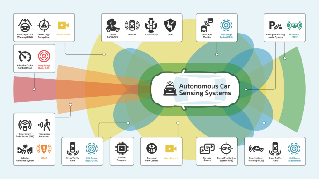
Foundational Layer: The
Role of Sensors in Enabling IoT for Autonomous Driving
The operation of autonomous vehicles hinges on their ability
to accurately perceive their surroundings, a capability primarily facilitated
by an array of sophisticated sensors. These sensors act as the eyes and ears of
the vehicle, gathering crucial data about the environment that is then
processed to make informed driving decisions. The data collected by these
sensors not only enables the basic functionalities of autonomous driving but
also forms the bedrock upon which various IoT applications are built.
LiDAR (Light Detection and Ranging) is a remote
sensing technology that uses laser beams to measure distances to surrounding
objects, creating precise three-dimensional maps of the environment. By
emitting short pulses of laser light and measuring the time it takes for the
light to return after reflecting off an object, LiDAR can calculate the
distance to that object with millimetre accuracy.
This technology can
detect objects at distances of 200-300 meters, providing a significant range
for the autonomous vehicle to perceive its surroundings. LiDAR systems utilize
infrared beams or laser pulses and can emit over a million points per second,
generating dense point clouds that enable detailed mapping.
Various types of LiDAR exist, including
Mechanical LiDAR systems operate with a rotating head
that houses multiple laser emitters and detectors. As the head spins, lasers
emit pulses of light, creating a wide horizontal field of view, and sometimes
vertical scanning. When these pulses hit objects, they reflect and are
detected. The system measures the time of flight for each pulse to calculate
distance, and as the head rotates, a dense 3D point cloud of the surroundings
is generated.
Advantages: A significant benefit of mechanical LiDAR
is its wide 360-degree horizontal field of view, providing comprehensive
environmental awareness. It typically offers high resolution and accuracy in
distance measurements due to multiple lasers and precise control. Being a
mature technology, it has a long history of development and refinement. In some
cases, mechanical LiDAR can also achieve longer detection ranges, which is
crucial for early object detection.
Disadvantages: The presence of moving parts in
mechanical LiDAR makes it more prone to mechanical failure, wear, and
vibration, potentially reducing long-term reliability. These systems are
generally bulkier and heavier than solid-state alternatives, which can impact vehicle
integration. They also tend to be more expensive due to the complexity of their
components. Furthermore, the moving parts make them more susceptible to shock
and vibration, and some configurations might have slower scan rates compared to
solid-state options.
Solid-state LiDAR systems differ significantly from
mechanical ones by eliminating the need for a rotating head. Instead, they
steer the laser beam electronically using various methods. One common approach
involves Micro-Electro-Mechanical Systems (MEMS), where tiny mirrors are
rapidly vibrated or tilted to direct the laser pulses. Another technique
utilizes optical phased arrays, which control the phase of light waves emitted
from multiple sources to steer the beam. Flash LiDAR is another type where a
single, powerful laser pulse illuminates the entire field of view at once, and
a sensor array captures the returning light. These methods allow for rapid and
precise beam steering without any macroscopic moving parts.
Advantages: The primary advantage of solid-state
LiDAR is the absence of moving parts, which leads to increased reliability,
durability, and resistance to shock and vibration. This design also allows for
significantly smaller and lighter sensors, making them easier to integrate into
vehicles and other platforms. With simpler designs and fewer components,
solid-state LiDAR has the potential for lower manufacturing costs at scale.
Furthermore, electronic beam steering often enables faster scan rates and the ability
to dynamically adjust the scanning pattern based on the situation.
Disadvantages: While rapidly advancing, solid-state
LiDAR technology is generally less mature compared to mechanical LiDAR. Current
limitations can include a potentially narrower field of view in some designs,
although this is constantly improving. Some types of solid-state LiDAR might
also have shorter detection ranges compared to certain high-performance
mechanical systems. The resolution and accuracy of solid-state LiDAR are also
areas of ongoing development and may not yet match the capabilities of some
high-end mechanical units in all scenarios.
Flash LiDAR operates by emitting a single, powerful
pulse of laser light that illuminates the entire field of view at once, similar
to a camera flash. Instead of scanning the laser beam point by point, the
entire scene is bathed in light simultaneously. The returning light, reflected
from all objects within the field of view, is then captured by a
two-dimensional array of highly sensitive detectors. Each pixel in the detector
array measures the intensity and the time of flight of the light that returns
to it, allowing the system to create a depth map of the entire scene in a
single shot.
Advantages: The primary advantage of Flash LiDAR is
its ability to capture the entire environment in a single laser pulse,
eliminating the need for any scanning mechanisms. This results in very high
frame rates, as the system isn't limited by the speed of mechanical rotation or
electronic beam steering. The absence of moving parts also contributes to
increased robustness, reliability, and a smaller form factor. Furthermore,
because the entire scene is captured simultaneously, Flash LiDAR is
particularly well-suited for capturing fast-moving objects and scenes without
motion distortion.
Disadvantages: One potential disadvantage of Flash
LiDAR is that for a given sensor size and laser power, the resolution might be
lower compared to scanning LiDAR systems that focus the laser energy on a
single point at a time. Achieving long detection ranges with Flash LiDAR can
also be challenging, as the laser energy is spread across the entire field of
view. This necessitates the use of powerful lasers and highly sensitive
detectors to capture enough returning light for accurate depth measurements.
Additionally, managing the heat generated by powerful, single-pulse lasers can
be a significant design consideration.
Frequency-Modulated Continuous-Wave (FMCW) LiDAR
continuously emits a laser beam whose frequency is constantly changing
(modulated) over time, often in a linear ramp or "chirp." When this
beam encounters an object, a portion of it is reflected back to the sensor. Due
to the continuous modulation, the frequency of the returning light is shifted
compared to the frequency of the light being emitted at that exact moment. This
frequency difference, known as the beat frequency, is directly proportional to
the distance to the object. By analyzing this beat frequency, the FMCW LiDAR
system can precisely determine the range to multiple points simultaneously
within its field of view.
Advantages: One significant advantage of FMCW LiDAR
is its ability to directly measure the velocity of objects using the Doppler
effect. The frequency shift in the returning light not only indicates distance
but also the relative speed of the object towards or away from the sensor. This
is particularly valuable for applications like autonomous driving where
understanding the motion of other vehicles and pedestrians is critical.
Additionally, FMCW LiDAR typically operates with lower peak power compared to
pulsed LiDAR, which can be beneficial for safety and power consumption.
Furthermore, because it uses a continuous wave with a specific frequency
modulation, it can be more resistant to interference from other LiDAR sensors
operating nearby.
Disadvantages: A potential drawback of FMCW LiDAR is
that achieving long detection ranges can be more challenging compared to
high-power pulsed LiDAR systems, although advancements are continuously being
made in this area. The signal processing required to extract the distance and
velocity information from the frequency-modulated signals can also be more
complex. Moreover, the accuracy of the frequency measurement, and therefore the
distance and velocity calculations, can be sensitive to the motion and vibrations
of the sensor itself, requiring sophisticated stabilization and compensation
techniques.
The selection of the appropriate LiDAR system involves
balancing factors such as wavelength, range, and resolution to meet the
specific needs of the autonomous vehicle.
 Fig 1 : Lidar perceiving the
surroundings. https://www.linkedin.com/pulse/lidar-smartest-sensor-self-driving-car-kumar-chellapilla/
Fig 1 : Lidar perceiving the
surroundings. https://www.linkedin.com/pulse/lidar-smartest-sensor-self-driving-car-kumar-chellapilla/
RADAR (Radio
Detection and Ranging) sensors function by emitting radio waves and
measuring the characteristics of the reflected waves to determine the speed,
distance, and position of surrounding objects.
This capability is crucial for maintaining safe following
distances and is often utilized in adaptive cruise control and collision
avoidance systems.
RADAR systems typically operate at frequencies of 24/77/79
GHz, with newer generations utilizing the 76-81 GHz band.
These sensors can have detection ranges spanning from a few centimetres
to several hundred meters.
Two primary types of RADAR used in autonomous vehicles are
impulse radar, which emits short pulses, and FMCW (Frequency Modulated
Continuous Wave) radar, which transmits a continuous signal with varying
frequencies.
A significant advantage of RADAR technology is its ability
to function reliably in adverse weather conditions such as fog, rain, and snow,
where other sensors like LiDAR and cameras may face limitations.
For instance, Waymo
utilizes radar in its sensor suite to obtain critical information about the
distance and speed of objects, ensuring reliable operation even in challenging
weather conditions. Furthermore, automotive radars are integral to Advanced
Driver Assistance Systems (ADAS), enabling features like lane change
assistance, emergency braking, and blind spot detection.
Cameras serve as the visual perception system for
autonomous vehicles, capturing images of the surroundings that are essential
for a wide range of tasks including lane-keeping, traffic signal recognition,
and object detection.
These sensors provide the visual intelligence necessary for
the vehicle to understand and interact with its environment based on visual
cues.
Modern autonomous vehicles typically employ CMOS image
sensors, often with a resolution of 1 to 2 megapixels. Camera systems can be
monocular (using a single lens) or stereo (using two lenses to provide depth
perception). A crucial technical requirement for these cameras is a high
dynamic range, typically exceeding 130 dB, to ensure clear image capture even
in challenging lighting conditions like direct sunlight. Different types of
cameras used in autonomous vehicles include RGB cameras that capture color information,
infrared cameras that detect heat signatures and operate in low light, and
trinocular cameras that use three lenses to provide a broader three-dimensional
view. A prominent example of camera-centric autonomous driving is Tesla's
Autopilot system, which relies heavily on camera-based technology.
Ultrasonic sensors operate by emitting
high-frequency sound waves and detecting the echoes that bounce back from
nearby objects, allowing for short-range detection and distance measurement.
These sensors are primarily used for parking assistance and
close-range object detection, providing essential proximity information for manoeuvring
in tight spaces. Ultrasonic sensors typically use sound waves in the frequency
range of 20 to 40 kHz and have an effective detection range of approximately
0.2 to 4 meters.
Compared to LiDAR and radar, ultrasonic sensors are less
complex and relatively inexpensive. They can operate effectively in any
lighting condition and are not affected by the colour or transparency of
objects. A common real-world application of ultrasonic sensors is in parking
assist systems, where they detect nearby obstacles during parking manoeuvres.
Earlier models of Waymo's autonomous vehicles also
incorporated ultrasonic sensors into their sensor suite.
Infrared sensors detect infrared radiation emitted by
objects, making them useful for night vision and identifying heat signatures of
pedestrians and animals. This technology enhances the autonomous vehicle's
ability to "see" in low-light conditions and identify warm objects
that might not be easily visible to other sensors.
Different types of infrared sensors are employed, including
Near-Infrared (NIR) sensor operates by detecting
light within the near-infrared portion of the electromagnetic spectrum,
typically ranging from about 700 nanometers to 1400 nanometers. These sensors
are designed to be sensitive to these specif ic
wavelengths. When NIR light strikes the sensor's detector material (often made
of materials like silicon, indium gallium arsenide (InGaAs), or lead sulfide),
it generates an electrical signal proportional to the intensity of the incoming
NIR radiation. There are two main types of NIR sensors: passive sensors, which
detect naturally occurring or ambient NIR light sources (like the sun or
thermal emissions), and active sensors, which emit their own NIR light source
(such as an LED or laser diode) and then detect the reflected or transmitted
light.
Advantages (Visibility and Penetration): One key
advantage of NIR sensors is their ability to "see" in conditions
where visible light is limited. NIR light experiences less scattering by
particles in the atmosphere, such as in light fog, haze, or smoke, allowing for
better visibility in these situations compared to visible light cameras. This
makes them valuable in applications like surveillance, autonomous driving, and
remote sensing where clear vision is crucial even in slightly adverse
conditions. Furthermore, NIR light can penetrate certain materials that are
opaque to visible light, enabling applications like detecting moisture content
in agricultural products or identifying counterfeit documents.
Advantages (Active Illumination and Material Detection):
Active NIR sensors offer the benefit of operating effectively even in complete
darkness. By emitting their own NIR light, which is invisible to the human eye,
they can illuminate a scene and capture detailed images or data based on the
reflected light. This is essential for night vision applications, security
systems, and autonomous vehicles operating at night. Additionally, different
materials reflect and absorb NIR light in unique ways, creating spectral
signatures. This property allows NIR sensors to be used for material
identification, sorting, and quality control in various industries, including
agriculture, pharmaceuticals, and recycling.
Disadvantages: Despite their advantages, NIR sensors
also have limitations. Their performance can be significantly affected by heavy
rain, dense fog, or thick smoke, as these conditions can still heavily scatter
NIR light. The range of active NIR sensors is limited by the power of the light
source and the sensitivity of the detector. Furthermore, while NIR can
penetrate some materials, it is absorbed by others, such as water, which can
limit its effectiveness in certain applications. The cost of high-performance
NIR sensors, especially those using specialized detector materials like InGaAs,
can also be higher compared to standard visible light sensors.
Short-Wave Infrared (SWIR) sensor detects light
within the 1000 to 3000 nanometer range of the electromagnetic spectrum,
utilizing specialized detector materials like Indium Gallium Arsenide (InGaAs)
or Mercury Cadmium Telluride (MCT). When SWIR photons strike these materials,
they generate an electrical signal proportional to the intensity of the
incoming radiation. SWIR sensors can operate passively by detecting existing
SWIR light or actively by using a SWIR light source for illumination and then
detecting the reflected or transmitted light.
Advantages: One
of the key advantages of SWIR sensors is their ability to see through certain
materials and atmospheric conditions that are opaque or scattering to visible
and near-infrared light, such as thin clouds, fog, smoke, and some plastics.
They are also highly sensitive to the presence of moisture, water, and ice due
to strong absorption at specific SWIR wavelengths, making them useful for
applications like detecting leaks, assessing plant health, and analyzing
geological formations. Furthermore, while not as pronounced as in other
infrared bands, SWIR sensors can still detect subtle temperature differences,
aiding in tasks like identifying overheating equipment or specific thermal
signatures.
Disadvantages: Despite these benefits, SWIR sensors
typically have a higher cost compared to visible and near-infrared sensors due
to the specialized materials and manufacturing processes. Some high-performance
SWIR detectors may also require cooling to minimize thermal noise, adding
complexity and power consumption. While they can penetrate certain obscurants,
SWIR light is still susceptible to scattering and absorption by very dense fog,
heavy rain, or thick smoke. Additionally, the performance of SWIR sensors can be
influenced by ambient temperature and humidity, necessitating careful
calibration in some applications.
Long-Wave Infrared (LWIR) sensors detect thermal
radiation emitted by objects due to their temperature, operating in the
approximate wavelength range of 8 to 15 micrometers. Unlike visible or
near-infrared sensors, LWIR sensors don't require an external light source as
they are sensitive to the heat naturally radiated by objects. The sensor's
detector, often made of materials like microbolometers or Mercury Cadmium
Telluride (MCT), absorbs this infrared energy, causing a change in its
electrical properties (e.g., resistance or voltage). This change is then
converted into an electrical signal that is proportional to the amount of
thermal radiation received, allowing for the creation of a thermal image.
Advantages: The primary advantage of LWIR sensors is
their ability to "see" in complete darkness, as they rely on the heat
emitted by objects rather than reflected light. This makes them invaluable for
night vision applications, surveillance, and security systems. They are also
highly sensitive to even small temperature differences between objects,
allowing for the detection of anomalies or variations that might not be visible
in other parts of the spectrum. LWIR technology has a wide range of applications,
including thermal imaging for building inspections (detecting insulation
issues), medical diagnostics (identifying areas of inflammation), industrial
maintenance (detecting overheating machinery), and search and rescue operations
(locating individuals based on their body heat).
Disadvantages: One of the main disadvantages of LWIR
sensors is that they typically have lower spatial resolution compared to
visible light cameras, meaning they might not capture as much fine detail in an
image. The accuracy of temperature measurements can also be affected by factors
such as the emissivity of the object being observed (how efficiently it
radiates heat) and environmental conditions. While uncooled LWIR sensors (like
microbolometers) are more affordable and easier to integrate, higher-performance
cooled LWIR detectors can offer better sensitivity and resolution but come with
a higher cost and often require a cooling mechanism, adding to the system's
complexity and power consumption
Unlike traditional cameras, infrared sensors cannot detect colour
and typically produce greyscale images.
 |
Fig 1 : Image depiction of sensors range in
localisation. https://knowhow.distrelec.com/wp-content/uploads/2021/11/sensor-tech-image1-2-1024x576.jpg
GPS/RTK GPS
(Global Positioning System/Real-Time Kinematic GPS) provides crucial
location information for autonomous vehicles. Standard GPS uses signals from
orbiting satellites to triangulate the vehicle's position. While standard GPS
offers an accuracy of around 5-10 meters, Real-Time Kinematic (RTK) GPS
significantly enhances this accuracy to the centimetre level by communicating
with a fixed base station that provides corrections to the satellite-based
positioning data.
RTK GPS systems rely on a base station with known
coordinates to cancel out errors in the satellite signals, achieving this high
level of precision. However, the accuracy of RTK GPS can degrade with
increasing distance from the base station. Autonomous vehicles utilize GPS and
RTK GPS for localization and mapping, providing the precise positioning
necessary for navigation.
IMU (Inertial Measurement Unit) is a vital sensor
that measures the vehicle's orientation, angular velocity, and linear
acceleration. IMUs track the vehicle's motion and rotation in three dimensions,
providing crucial data about its attitude and movement.
A typical IMU contains accelerometers that measure linear
acceleration and gyroscopes that measure rotational rates, some also include
magnetometers for heading reference. These sensors provide measurements over 6
degrees of freedom, capturing the vehicle's movement along three axes and its
rotation around three axes.
IMUs are particularly important for dead reckoning
navigation, allowing the autonomous vehicle to estimate its position and
trajectory even when GPS signals are unavailable or unreliable.
High-performance IMUs are essential for achieving the
accuracy required in automotive applications. In practice, IMU data is often
integrated with GPS and odometer readings using sensor fusion techniques like
the Extended Kalman Filter (EKF) to obtain a more accurate and robust
localization estimate.
The combined use of Accelerometers, Magnetometers and
Gyroscopes is fundamental to providing a comprehensive understanding of
a vehicle's motion and orientation, particularly in autonomous systems. Each
sensor contributes unique information that, when fused together, creates a more
robust and accurate picture than any single sensor could provide on its own.
Accelerometers measure linear acceleration, essentially the
rate of change of velocity. They can sense forces acting on the vehicle,
including gravity, which allows them to provide information about the vehicle's
orientation relative to the Earth, specifically its roll (tilting side to side)
and pitch (tilting forward or backward). However, accelerometers are sensitive
to all linear accelerations, meaning that during movement, it can be
challenging to isolate the effect of gravity from the acceleration of the
vehicle itself.
Magnetometers measure the strength and direction of magnetic
fields. In the context of autonomous vehicles, they are primarily used as a
digital compass to determine the vehicle's heading relative to magnetic north.
This provides crucial information about the vehicle's yaw, or its rotation
around a vertical axis. However, magnetometers can be susceptible to
interference from local magnetic anomalies, such as those caused by the
vehicle's own electronics or nearby metallic structures, which can affect their
accuracy.
Gyroscopes, or gyros, measure angular velocity, which is the
rate at which an object is rotating around its axes (roll, pitch, and yaw).
They provide very precise measurements of changes in orientation over short
periods. This is essential for tracking how the vehicle is turning or rotating.
However, gyroscopes tend to accumulate small errors over time, a phenomenon
known as drift, which can lead to inaccuracies in long-term orientation
estimates if not corrected.
By combining the data from these three sensors through a
process called sensor fusion (often using algorithms like Kalman filters), the
strengths of each sensor can compensate for the weaknesses of the others. For
example, the accelerometer can provide a relatively stable long-term reference
for roll and pitch, correcting for drift in the gyroscope's measurements of
these angles. The magnetometer can offer an absolute heading reference,
counteracting the gyroscope's yaw drift. The gyroscope, being very sensitive to
changes in rotation, can provide accurate short-term orientation updates, even
during dynamic manoeuvres where accelerometer readings might be dominated by
linear accelerations. This fused data is crucial for various aspects of
autonomous driving, including accurate navigation (especially when GPS signals
are weak or unavailable), precise vehicle control, and a comprehensive
understanding of the vehicle's motion within its environment.
Environmental Sensors in autonomous vehicles monitor
the surroundings beyond physical objects, including auditory cues, atmospheric
conditions, and even contact with the environment. These sensors provide a more
holistic understanding of the driving context. This category can include
various sensor types, such as microphones to detect sounds like honks and
sirens, humidity sensors, thermometers, vibration sensors, and gas sensors.
Waymo's 6th
generation autonomous vehicles, for example, utilize an array of audio sensors
to recognize important sounds in the driving environment. This allows the
vehicle to react appropriately to auditory signals from other road users or
emergency services.
Odometer is an instrument used to measure the
distance traveled by a vehicle. In the context of autonomous vehicles, while
not a primary sensor for perceiving the environment in the same way as cameras
or LiDAR, the odometer plays a supporting yet important role in several aspects
of operation.
Firstly, the odometer provides fundamental information about
the total distance the autonomous vehicle has covered. This data can be crucial
for vehicle maintenance scheduling, tracking usage for fleet management, and
potentially for billing purposes in autonomous ride-sharing services.
Secondly, odometer readings contribute to the vehicle's
localization and navigation capabilities. While autonomous vehicles heavily
rely on GPS, LiDAR, and cameras for precise positioning, odometer data can be
used in conjunction with these sensors for a technique called dead reckoning.
This involves estimating the vehicle's current position based on its last known
location and the distance travelled since then. This is particularly useful in
situations where GPS signals might be weak or temporarily unavailable, such as
in tunnels or urban canyons. By integrating odometer data with information from
other sensors like Inertial Measurement Units (IMUs), a more continuous and
reliable estimate of the vehicle's position and motion can be achieved through
sensor fusion.
Furthermore, modern electronic odometers often derive their
readings from wheel speed sensors. This wheel speed information is not only
used for calculating distance but is also vital for other critical autonomous
driving functions, such as vehicle dynamics control systems like Anti-lock
Braking Systems (ABS) and traction control. Additionally, odometer data can be
valuable in the process of creating and updating maps used for autonomous
navigation, as knowing the precise distance traveled between sensor readings
helps in accurately georeferencing and calibrating the map data.
|
Sensor Type |
Functionality |
Detection Range |
Accuracy |
Strengths |
Limitations |
Typical Applications in Autonomous
Vehicles |
|
LiDAR |
Creates
3D maps using laser beams |
200-300
meters |
High |
Precise
3D mapping, excellent object detection |
Expensive,
affected by adverse weather (fog, rain, snow) |
Detailed
environmental mapping, obstacle detection, pedestrian and vehicle tracking |
|
RADAR |
Detects distance and speed of objects using
radio waves |
Up to 200 meters |
Medium |
Effective in adverse weather, measures
velocity |
Lower resolution compared to LiDAR, can
produce false positives |
Adaptive cruise control, collision
avoidance, blind spot detection, cross-traffic alerts |
|
Cameras |
Captures
visual data of surroundings |
Varies |
Medium
to High |
Vital
for visual recognition (traffic lights, signs, pedestrians), cost-effective |
Performance
affected by lighting and weather conditions |
Lane
keeping assist, traffic sign recognition, object detection, pedestrian
detection |
|
Ultrasonic Sensors |
Short-range obstacle detection using sound
waves |
Up to 5.5 meters |
Low to Medium |
Inexpensive, effective for short-range
detection |
Short range, narrow field of view,
difficulty detecting fast-moving objects |
Parking assistance, close-range obstacle
detection, stop-and-go traffic |
|
Infrared Sensors |
Detects
thermal signatures and enhances visibility in low light |
Short
to Medium |
Medium |
Improved
visibility in darkness and adverse conditions |
Can
be affected by temperature variations |
Pedestrian
and animal detection in low light, complementing camera systems |
|
GPS/RTK GPS |
Determines vehicle location using satellite
signals |
Global |
Meter/ Centimetre |
Wide coverage, RTK offers high precision |
Accuracy can be affected by obstructions
(tunnels, buildings), standard GPS has meter-level accuracy |
Navigation, localization, fleet management,
geofencing |
|
IMU |
Measures
orientation, angular velocity, and linear acceleration |
Internal |
High |
Provides
precise motion data, complements GPS |
Can
drift over time, requires integration with other sensors |
Motion
tracking, vehicle dynamics control, sensor fusion algorithms |
|
Environmental |
Monitors conditions like humidity,
temperature, gas levels, and ambient noise |
Varies |
Varies |
Provides additional contextual awareness |
Accuracy and reliability depend on sensor
type and quality |
Detecting hazardous conditions, recognizing
emergency vehicle sirens, contributing to smart city data |
|
Odometer |
Measures distance travelled by counting
wheel rotations |
Vehicle-dependent |
High |
Reliable measure of distance travelled |
Can be affected by tire slippage |
Localization, navigation, tracking
vehicle usage in fleet management |
Sensor Fusion: Algorithms
and Techniques Used to Combine Data from Different Sensors
Defining Sensor Fusion in the Context of AVs
Sensor fusion, also referred to as multisensory data fusion
or sensor data fusion, is the process of combining output data from different
sensors to enhance the accuracy and reliability of detection tasks in
autonomous vehicles. This technique aims to create a single, more reliable
dataset by integrating data from two or more distinct sensors that provide
information about the same event or environment. The sophistication of sensor
fusion lies in its ability to intelligently combine diverse data sources, going
beyond simple aggregation to construct a coherent and dependable understanding
of the surroundings. This is achieved by strategically leveraging the unique
strengths inherent in different sensor technologies.
The Purpose of Sensor Fusion
The primary purpose of sensor fusion in autonomous vehicles
is to enhance the reliability and versatility of the vehicle's perception and
localization capabilities. It serves to improve the specific detection task and
ultimately ensure a high level of reliability and safety for human occupants
and other road users. By integrating the strengths of various sensors, sensor
fusion aims to overcome the inherent limitations and weaknesses associated with
relying on any single sensor. This comprehensive approach enables autonomous
vehicles to effectively navigate and comprehend their surrounding environment
in a multitude of driving scenarios. The overarching purpose, therefore, is to
create a robust and dependable perception system that allows autonomous vehicles
to operate safely and effectively across diverse and challenging real-world
conditions by mitigating the individual shortcomings of each sensor.
Key Benefits of Sensor Fusion
Sensor fusion offers numerous and significant benefits for
autonomous vehicles, primarily contributing to enhanced safety and operational
reliability.
Improved Detection Accuracy
Combining data from different sensors leads to a more
accurate detection of objects, including crucial parameters such as their
position, velocity, and classification. For instance, while cameras excel at
object recognition and classification, radar is superior in measuring distance
and velocity, especially in adverse weather, and lidar provides high-resolution
3D mapping essential for localization and environmental structure
understanding. The synergistic combination of these diverse sensor modalities,
often through raw data fusion, improves the signal-to-noise ratio, resulting in
better detection and fewer false alarms, particularly for small and
unclassified objects. Furthermore, the fusion process can help overcome the
limitations of single sensor faults, ensuring a more consistent and reliable
perception. This enhanced accuracy stems from the ability of the system to
leverage the strengths of each sensor and compensate for their individual
weaknesses, leading to a more precise and reliable understanding of the
environment.
Enhanced Robustness and
Reliability
Sensor fusion significantly improves the robustness of the
perception system by providing redundancy; if one sensor is impaired by weather
conditions or malfunctions, other sensors can still provide critical
information, ensuring continued operation. This allows autonomous vehicles to
operate reliably in a wider variety of environments by compensating for the
limitations of individual sensors in different conditions. The built-in
redundancy within sensor fusion solutions inherently increases the overall reliability
of the autonomous driving system. This increased robustness is crucial for
ensuring the safety and dependability of autonomous vehicles, as it allows the
system to maintain a consistent level of environmental awareness even when
individual sensors face challenges or failures.
Extended Detection Range
and Field of View
By fusing data from sensors with complementary detection
ranges and fields of view, the autonomous vehicle can achieve a more extensive
and complete understanding of its surroundings. For example, long-range radar
can detect objects at greater distances, providing early warnings, while
cameras and lidar can offer more detailed information about closer objects. The
ability to integrate data from sensors with varying detection capabilities
allows sensor fusion to provide a more holistic view of the environment,
encompassing both near and far objects, which is essential for proactive and
safe navigation.
Better Object
Classification and Tracking
Sensor fusion enhances the ability of the autonomous vehicle
to classify different types of objects (e.g., pedestrians, vehicles, cyclists)
and track their movement accurately by combining visual information from
cameras with distance and velocity data from radar and the 3D point clouds from
lidar. Advanced tracking algorithms can utilize temporal information from the
fused data to further refine detection results and add a velocity vector to
each object, improving the prediction of their future behavior. This enhanced
classification and tracking enable autonomous vehicles to better understand the
behavior of other agents in the environment, leading to more informed and safer
decision-making.
Increased Overall Safety
Ultimately, the primary benefit of sensor fusion in
autonomous vehicles is the increase in overall safety. By providing a more
accurate, reliable, and comprehensive understanding of the driving environment,
sensor fusion enables the vehicle to make better decisions and avoid accidents.
It also helps compensate for inherent errors in individual sensors, leading to
a more dependable driving system. All the aforementioned benefits of sensor
fusion converge towards this ultimate goal of significantly enhancing the
safety of autonomous vehicles for both occupants and other road users.
|
Sensor Type |
Key Strengths |
Key Weaknesses |
|
Cameras |
High-resolution
visual data, object recognition (traffic signs, lane markings), rich color
and texture information |
Limited
performance in low light and adverse weather, no direct 3D information |
|
Lidar |
High-resolution 3D mapping, precise object
detection and ranging, robust to illumination variations |
Performance
degradation in heavy fog, rain, and snow |
|
Radar |
Long-range
object detection, velocity measurement, robustness in adverse weather
conditions |
Lower
resolution compared to lidar and cameras, poor detection of small objects |
|
Ultrasonic sensor |
Short-range obstacle detection, low cost |
Limited
range and field of view, susceptible to interference and environmental noise,
difficulty detecting fast-moving or small objects |
|
Odometry |
Estimation
of vehicle motion, relative position information |
Susceptible
to drift and wheel slippage, accuracy degrades over time |
|
Environmental |
Monitoring weather and road surface
conditions, provides context for other sensors |
Indirect
contribution to core driving tasks, accuracy depends on sensor quality |
|
GPS |
Global
positioning for localization and navigation, absolute position information |
usceptible
to signal blockage in urban canyons, tunnels, and indoors, limited accuracy
without augmentation |
|
IMU |
Measures inertial motion (acceleration,
angular rates, orientation), high-frequency data |
Prone
to drift over time, requires fusion with other sensors for absolute
positioning |
|
IR Sensors |
Detects
heat signatures for object detection in low visibility, differentiates
between living beings and inanimate objects |
Lower
resolution compared to cameras and lidar, cannot detect colors. |
The Process of Sensor Fusion
The process of sensor fusion in autonomous vehicles involves
several critical stages to integrate data from diverse sensors and create a
comprehensive and accurate understanding of the vehicle's surroundings.
Key Stages in the Fusion
Process
The sensor fusion process typically encompasses several key
stages to transform raw sensor data into actionable information for autonomous
driving.
Data Acquisition
The initial stage involves gathering raw data from the array
of sensors mounted on the vehicle, including cameras, lidar, radar, ultrasonic
sensors, as well as other sensors like GNSS (Global Navigation Satellite
System) and IMU (Inertial Measurement Unit). Each sensor captures specific
types of information about the environment based on its operating
principles.
Data Preprocessing
Once the raw data is acquired, it undergoes preprocessing to
enhance its quality and reliability. This may include steps such as noise
reduction to eliminate spurious readings, applying filters to smooth the data,
and potentially calibrating individual sensor data to correct for inherent
biases or inaccuracies.
Data Alignment
(Synchronization and Registration)
To effectively fuse data from multiple
sensors, it is crucial to align the data both temporally and spatially.
·
Temporal Alignment (Synchronization):
This involves synchronizing data from different sensors that may operate at
varying sampling rates and experience communication delays to a common time
reference. Techniques such as using timestamps associated with each data point
and employing interpolation methods are utilized to achieve temporal
consistency. Accurate temporal alignment is particularly critical for fusing
high-speed sensor data like that from GPS and IMU, as it directly impacts the
accuracy of motion estimation and object tracking.
·
Spatial Alignment (Registration): This
step focuses on transforming sensor data from their individual coordinate
frames to a common reference frame, accounting for the different positions and
orientations of the sensors on the vehicle, often referred to as the lever arm.
This transformation typically involves calibration procedures to precisely
determine the mounting parameters of each sensor relative to the vehicle's
coordinate system. Accurate spatial alignment is essential for tasks like 3D
reconstruction of the environment and precise object localization.
Data Fusion
After preprocessing and alignment, the data from different
sensors is combined using various algorithms and techniques. The specific
methods employed depend on the level of fusion (early, late, or mid-level) and
the types of sensors being integrated. The goal of this stage is to create a
unified representation of the environment that is more informative and reliable
than what could be obtained from any single sensor alone.
Perception and
Interpretation
The fused data is then processed and interpreted to extract
meaningful information about the vehicle's surroundings. This involves tasks
such as detecting and identifying various objects (e.g., pedestrians, vehicles,
traffic signs), classifying these objects based on their type and relevance,
and tracking their movement over time. Additionally, this stage includes
understanding the overall scene, such as identifying road geometry and
detecting free space for navigation.
Action and Control
Finally, the interpreted information from the perception
stage is used to make decisions about the vehicle's behavior and to generate
control commands for safe and efficient navigation. This may involve planning a
path, adjusting the vehicle's speed, changing lanes, or taking evasive actions
to avoid obstacles.
Addressing the Challenges
of Data Diversity
A significant challenge in sensor fusion is the inherent
diversity of data produced by different sensors. These sensors vary in their
accuracy, resolution, and noise characteristics. They also differ in their
physical units of measurement, sampling resolutions, and spatio-temporal
alignment. Furthermore, there is inherent uncertainty in the data sources,
including noise, calibration errors, quantization errors, precision losses,
differences in reliability, inconsistent data, and missing values. To overcome these
challenges, robust algorithms are essential. These algorithms must be capable
of managing the inconsistencies between sensor outputs and transforming the
diverse data into a common format that can be effectively utilized by the
decision-making systems of the autonomous vehicle. The sensor fusion process,
therefore, is a multi-stage operation that demands precise synchronization,
alignment, and sophisticated algorithms to effectively integrate heterogeneous
data from various sensors into a unified and meaningful representation of the
driving environment, enabling safe autonomous navigation.
Levels and Architectures of Sensor Fusion
Sensor fusion in autonomous vehicles can be implemented at
different levels of abstraction, each with its own advantages and
disadvantages. These levels are generally categorized as early fusion, late
fusion, and mid-level fusion. Additionally, the overall architecture of the
sensor fusion system can be centralized, distributed, or a hybrid of both.
Early Fusion (Raw Data Level / Low-Level Fusion)
Early fusion involves combining the raw data from multiple
sensors at the pixel or signal level before any high-level processing or
decision-making takes place. For example, this could involve fusing raw pixel
data from cameras with raw point cloud data from lidar to create a dense 3D
environmental RGBD model. Another instance is aligning raw data between sensors
at the pixel or signal level , or projecting lidar points into the image plane
and associating them with 2D detections. A key advantage of early fusion is
that it allows the neural network to exploit correlations between low-level
features from different sensors, providing a more information-rich input to
learning models. It can also improve the signal-to-noise ratio, enable the
system to overcome single sensor faults, and allow for the use of lower-cost
sensors. However, early fusion also has drawbacks. It increases the
dimensionality of the feature space, which can make learning more difficult,
especially with limited training data. This approach requires precise
synchronization and calibration of the sensors and can be computationally
intensive. Furthermore, it tends to be less modular and more sensitive to
sensor noise and failures. Early fusion has the potential to extract rich and
nuanced information by combining raw sensor data, enabling the exploitation of
low-level correlations, but it demands stringent data alignment and significant
computational resources, making it a complex approach to implement effectively.
Late Fusion (Decision Level / High-Level Fusion)
In late fusion, data from each sensor is processed
independently to generate local predictions or decisions (e.g., detecting
objects, classifying them), and these individual results are then combined at a
higher level to make the final fused prediction or decision. An example of this
is running 3D object detection on lidar point clouds and 2D object detection on
camera images, then projecting the 2D detections into the 3D space and fusing
them with the 3D detections. Another example involves combining symbolic
representations such as detected objects or trajectories to arrive at a more
probable overall decision. Late fusion offers several advantages, including
being more modular and fault-tolerant since each sensor operates independently
(if one fails, the system can often continue to operate using data from the
other sensors). It is also generally less computationally intensive than early
fusion and easier to implement. However, a key disadvantage is that the
perception models only process data from one sensor at a time, so they cannot
leverage any cross-sensor interactions at a low level. Additionally, this
approach might reject classifications with lower confidence, potentially
leading to insufficient information, and it relies heavily on the performance of
the individual sensor processing pipelines. Late fusion offers a more flexible
and computationally efficient approach by integrating high-level outputs from
individual sensors, making it easier to implement and more robust to sensor
failures, but it may miss subtle correlations present in raw data and is
limited by the quality of individual sensor processing.
Mid-Level Fusion (Feature Level)
Mid-level fusion involves the fusion of characteristics and
features (shapes, textures, their positions) that have been extracted from the
sensor data. For instance, this could involve fusing edge detection features
from a camera feed with point cloud data from a lidar sensor to improve object
detection and classification, or fusing visual features with lidar points.
Techniques like Kalman filters are often employed in mid-level fusion to
combine object-level data. Mid-level fusion represents a compromise between
early and late fusion, aiming to leverage some of the benefits of cross-sensor
interaction by combining extracted features while still maintaining a degree of
modularity and potentially lower computational cost than early fusion.
Sensor Fusion Architectures
Beyond the level of fusion, the architecture
of the sensor fusion system also plays a crucial role. Common architectures
include:
·
Centralized Fusion: In this architecture,
all raw data from all sensors is transmitted to a central processing unit where
it is fused and analysed. This approach provides a global view of the system
state but can be computationally intensive and represents a single point of
failure.
·
Distributed Fusion: Here, each sensor or
a group of sensors performs some initial processing, and the resulting
information is then fused with data from other sensors or processing units.
This improves scalability and fault tolerance but requires efficient
communication protocols between the nodes.
·
Hybrid Approaches: These architectures
combine elements of both centralized and distributed fusion to leverage the
advantages of each, offering flexibility in system design.
The choice of fusion level and architecture in autonomous
vehicles is a critical design decision that involves balancing the need for
comprehensive data integration with constraints on computational resources,
system complexity, and robustness, ultimately depending on the specific
application and requirements of the autonomous vehicle.
Conditions for Effective Sensor Fusion
The effectiveness of sensor fusion in autonomous vehicles is
highly dependent on the specific driving scenario and the conditions under
which different sensor combinations are utilized.
Combining Camera and Lidar
The combination of camera and lidar is particularly
beneficial for object detection and classification, as well as for achieving
accurate depth perception and creating detailed 3D maps in a variety of
lighting conditions. Lidar excels at providing accurate distance measurements
and 3D structural information, while cameras offer rich colour and texture
details. This complementary nature allows them to compensate for each other's
weaknesses in varying lighting (day versus night). While both can be affected
by severe weather conditions like heavy fog or snow, their combined use
enhances the overall robustness of the perception system.
Using Radar for Long-Range Detection in Adverse Weather
Radar's unique ability to penetrate through fog, rain, and
snow makes it indispensable for long-range detection of vehicles and other
obstacles in conditions where cameras and lidar may be severely limited.
Furthermore, radar's capability to directly measure the velocity of objects
adds another crucial layer of information for autonomous driving systems.
Combining Radar and Lidar
The fusion of radar and lidar can be particularly effective
for surface detection in adverse conditions. This combination leverages lidar's
high spatial resolution in range, azimuth, and elevation with radar's ability
to penetrate obscuring media, offering a more robust perception even when
visibility is poor.
Using Ultrasonic Sensors for Short-Range Detection
Ultrasonic sensors are most useful in low-speed scenarios,
such as parking assistance and detecting obstacles at close range. Their low
cost and ability to sense various types of materials make them a valuable
addition to the sensor suite for these specific applications.
Integrating GNSS and IMU with Other Sensors
The integration of GNSS (Global Navigation Satellite System)
and IMU (Inertial Measurement Unit) data with other sensor inputs is critical
for achieving accurate localization and navigation. This is particularly
important in situations where GNSS signals may be weak or unavailable, such as
in urban canyons or tunnels. The IMU helps to compensate for the drift inherent
in GNSS signals and provides crucial inertial data about the vehicle's motion
and orientation.
The selection of the optimal sensor combination through
fusion is therefore highly context-dependent, determined by the specific
driving scenario and the limitations of each individual sensor under those
conditions.
Examples of How Sensor Fusion Enables Specific Autonomous Driving
Capabilities
Sensor fusion is a fundamental enabler for various critical
autonomous driving capabilities, providing the necessary accuracy, reliability,
and robustness for the vehicle to perceive, plan, and navigate safely and
effectively.
Object Detection
Sensor fusion plays a pivotal role in object detection by
combining the strengths of different sensors. Camera imagery provides visual
recognition, lidar offers precise 3D positioning and depth information, and
radar contributes velocity measurements and long-range detection capabilities.
By fusing these diverse data streams, autonomous vehicles can accurately
detect, classify, and track a wide range of objects, including pedestrians,
vehicles, and obstacles, across various driving conditions and environmental
scenarios.
Lane Keeping
Maintaining the vehicle within its lane requires precise
perception of lane markings and the vehicle's position relative to these
boundaries. Sensor fusion enables this by combining camera data for lane
marking detection with lidar or radar to accurately determine the vehicle's
lateral position within the lane. This fused information allows the vehicle's
control system to make the necessary steering adjustments to ensure it stays
safely within the lane.
Path Planning
Planning a safe and efficient path for the autonomous
vehicle relies on a comprehensive understanding of its surroundings. Sensor
fusion provides this understanding by integrating data from all relevant
sensors. By combining this environmental data with accurate localization
information (often derived from the fusion of GPS and IMU data), the vehicle
can plan optimal routes, make informed decisions about lane changes and turns,
and effectively avoid any detected obstacles.
Localization
Accurate and robust localization, determining the vehicle's
precise position within its environment, is fundamental to autonomous driving.
Sensor fusion achieves this by combining data from multiple sources, including
GPS, IMU, lidar, radar, cameras, and wheel speed sensors. This is particularly
crucial in challenging environments where GPS signals may be unreliable, such
as urban canyons or tunnels. Sensor fusion is also an integral component of
Simultaneous Localization and Mapping (SLAM) techniques used by autonomous
vehicles.
These examples illustrate that sensor fusion is not just an
enhancement but an essential technology that underpins the core functionalities
of autonomous driving, providing the necessary accuracy, reliability, and
robustness for safe and effective operation.
Defining the Internet of Things (IoT) in the Context of Autonomous Vehicles
The integration of the Internet of Things (IoT) into
autonomous vehicles (AVs) heralds a paradigm shift in transportation, moving
beyond isolated vehicles to a network of intelligently connected entities. This
interconnectedness allows AVs to function as dynamic data hubs, continuously
gathering and disseminating information vital for safe and efficient operation.
Onboard sensors, the "sensory organs" of AVs, generate a deluge of
data about the vehicle's surroundings, which is then shared with neighbouring vehicles
(V2V), roadside infrastructure (V2I), pedestrians (V2P), and cloud-based
platforms. This data exchange enables real-time traffic management, cooperative
driving manoeuvres, and proactive hazard detection.
Furthermore, the IoT facilitates access to cloud-based
services, empowering AVs with up-to-the-minute traffic updates, dynamic
navigation, and over-the-air software updates. This constant connectivity not
only optimizes route planning and fuel consumption but also enables remote
diagnostics and predictive maintenance, minimizing downtime and enhancing
overall reliability. In emergency scenarios, the ability to automatically
transmit location and sensor data to emergency services can significantly
improve response times.
However, the widespread deployment of IoT-enabled AVs
necessitates addressing several critical challenges. Data security and privacy
are paramount, requiring robust encryption and authentication mechanisms to
protect sensitive information. Network reliability and low-latency
communication are crucial for real-time decision-making, demanding resilient
and high-bandwidth infrastructure. Standardization of communication protocols
is essential for interoperability between diverse AV systems and infrastructure
components. Finally, cybersecurity threats pose a significant risk, requiring
comprehensive security measures to safeguard against malicious attacks that
could compromise vehicle safety. Overcoming these challenges is crucial to
fully realizing the potential of IoT in creating a safer, more efficient, and
interconnected transportation ecosystem.
Categorizing IoT Applications in Autonomous Cars
The integration of the Internet of Things (IoT) into
autonomous vehicles has paved the way for a wide array of applications that
enhance safety, efficiency, convenience, and overall functionality. These
applications can be broadly categorized based on their primary function and the
type of data exchanged.
V2X (Vehicle-to-Everything) communication is a
critical category of IoT applications in autonomous vehicles, enabling them to
communicate with their surroundings. This communication relies on wireless
technologies such as Dedicated Short-Range Communication (DSRC) and
Cellular-V2X (C-V2X), with 5G connectivity further enhancing its capabilities.
The data exchanged through V2X includes vital information about speed,
position, direction, braking patterns, road conditions, traffic light status,
hazard warnings, and the presence of pedestrians. Standardized message types
like Basic Safety Messages (BSM), Traveler Information Messages (TIM), and MAP
Messages facilitate this data exchange. The benefits of V2X are numerous,
including improved situational awareness beyond the capabilities of onboard
sensors, proactive collision prevention, enhanced traffic flow through
cooperative driving, real-time hazard warnings, increased pedestrian safety,
faster response times for emergency vehicles, and crucial support for autonomous
driving functionalities. However, the widespread implementation of V2X faces
challenges such as the need for significant infrastructure investment,
cybersecurity and data privacy concerns, and the standardization of
communication protocols across different regions and manufacturers. Specific
examples of V2X applications include emergency electronic brake light warnings,
forward collision warnings, blind spot warnings, lane change assistance,
intersection movement assistance, green light speed advice, and alerts for
vulnerable road users. Companies like Volkswagen are already equipping their
latest vehicle models with V2X technology.
|
Feature |
DSRC (802.11p) |
C-V2X (Cellular V2X) |
|
Communication Modes |
Primarily
V2V and V2I |
V2V,
V2I, V2P (direct communication via PC5 interface) V2N
(via cellular network) |
|
Frequency Band |
Dedicated
ITS 5.9 GHz spectrum (5.875-5.905 GHz) |
Dedicated
ITS 5.9 GHz spectrum leverages
existing LTE and 5G networks |
|
Range (Line of Sight) |
~675
meters |
~1175
meters |
|
Latency |
Low
(<100 ms) |
Low
(comparable to DSRC for PC5 interface) |
|
Reliability |
High
for direct communication |
High
for both direct and network-based communication |
|
Standardization Status |
Mature
standard, deployed in some regions |
Evolving
standard, gaining increasing adoption |
|
Current Adoption |
Limited
adoption in new vehicles |
Growing
adoption by automakers and infrastructure developers |
OTA Updates (Over-the-Air Updates) represent another
essential category of IoT applications, allowing for the wireless delivery of
software updates to autonomous vehicles. These updates are facilitated by
wireless communication technologies like Wi-Fi and cellular networks, and
managed by the vehicle's telematics control unit (TCU). The data exchanged
includes software patches, new features, performance enhancements, security
updates, map data, and infotainment upgrades. OTA updates offer numerous
benefits, such as convenience for vehicle owners by eliminating the need for
dealership visits, improved vehicle longevity through continuous software
refinement, enhanced security and safety through remote patching of
vulnerabilities, cost savings for both manufacturers and consumers, and the
ability to introduce new features and functionalities even after the vehicle
has been purchased. Despite these advantages, challenges exist, including the
reliance on a stable internet connection, potential cybersecurity risks during
the update process, and ensuring compatibility with older vehicle hardware.
Tesla has been a pioneer in utilizing OTA updates for its
vehicles , and other manufacturers like Volkswagen and Cadillac are also
implementing this technology.
Real-Time Traffic Data Integration is a vital IoT
application that allows autonomous vehicles to access and utilize live
information about traffic conditions. This integration involves various
technologies, including IoT devices like sensors and cameras deployed across
road networks, GPS data from vehicles and mobile devices, traffic management
centers, mobile applications, and sophisticated data analytics tools powered by
AI algorithms. The data exchanged encompasses traffic flow, vehicle speeds,
congestion levels, incident reports, road closures, weather conditions,
construction zones, and traffic signal timings. The benefits of this
application are significant, including dynamic route planning to avoid
congested areas, optimization of overall traffic flow, reduction in travel
times and fuel consumption, proactive traffic management by authorities, and
improved safety through early warnings about hazards. However, challenges
remain in ensuring the accuracy and reliability of data from diverse sources, as
well as addressing concerns related to data privacy and security.
Examples of real-time traffic data integration include
Google's self-driving project , AI-powered traffic signal adjustments in cities
like Los Angeles and London , and dynamic lane management systems that adapt to
traffic flow.
IoT for Fleet Management is a crucial application for
autonomous vehicles deployed in commercial fleets, enabling efficient operation
and resource utilization. This involves technologies such as GPS trackers,
various sensors monitoring vehicle condition and performance, telematics
devices, and cloud-based platforms accessible through mobile and web
applications. The data exchanged includes real-time vehicle location,
condition, fuel consumption, driver behavior (if applicable), maintenance
needs, routes taken, and cargo status. The benefits of IoT in fleet management
are substantial, including real-time tracking and monitoring of vehicles,
predictive maintenance capabilities, optimization of fuel consumption,
monitoring and improvement of driver safety, efficient asset tracking and
management, optimized route planning and scheduling, enhanced security against
theft, and overall cost savings and increased operational efficiency. Despite
these benefits, challenges exist, such as the high initial costs of implementing
these systems, concerns about data security, and the complexity of integrating
various technologies.
Companies like Intel,
Advantech, Passengera, UPS, and DHL have successfully implemented IoT for fleet
management.
Predictive Maintenance is another significant IoT
application in autonomous vehicles, utilizing sensor data and analytics to
forecast when maintenance will be required. This involves technologies like IoT
sensors embedded in various vehicle components, cloud-based analytics centers,
and predictive analytics techniques powered by AI and machine learning
algorithms. The data exchanged includes vehicle condition data, fuel
consumption, engine temperature, tire pressure, brake condition, coolant
levels, battery health, and motor performance. The benefits of predictive
maintenance are substantial, including the ability to forecast when vehicle
parts need upgrading, maintenance, or replacement, detecting pre-failure
conditions, reducing vehicle downtime and repair costs, improving overall
vehicle safety and reliability, and extending the lifespan of vehicle
components. Implementing predictive maintenance requires data collection
infrastructure, advanced analytics capabilities, and investment in AI
technology.
Leading automotive companies like Tesla, General Motors
(OnStar), BMW, and Daimler (Mercedes-Benz) are already leveraging AI for
predictive maintenance in their vehicles.
Integration with Smart Cities represents a future
trend where autonomous vehicles will seamlessly interact with urban
infrastructure to enhance mobility and efficiency. This integration involves
technologies such as connected infrastructure (traffic lights, road sensors,
parking lots), cloud technologies, data analytics, AI, and V2I communication.
The data exchanged includes traffic flow data, information about available
parking spaces, road conditions, weather data, traffic signal timings, and
potential hazards. The benefits of this integration are numerous, including
improved traffic flow, reduced congestion and emissions, easier parking for
drivers, enhanced safety through infrastructure-based alerts, optimized energy
usage within the transportation network, support for ridesharing and robo-taxi
services, and better overall urban planning based on transportation data.
However, achieving seamless integration with smart cities requires significant
infrastructure development and upgrades, careful consideration of data privacy
and security, and ensuring interoperability between the diverse systems
involved.
Examples of early integration efforts include smart parking
solutions that provide real-time data on parking availability , connected
vehicles that can find open parking spaces and recommend optimal routes , and
autonomous vehicles that communicate with adaptive traffic lights to optimize
signal timings.
|
IoT Application |
Technologies Involved |
Data Exchanged |
Key Benefits |
Key Challenges |
Specific Examples |
|
V2X |
DSRC,
C-V2X, 5G |
Speed,
position, road conditions, traffic signals, hazards, pedestrian presence |
Improved
safety, traffic flow, situational awareness |
Infrastructure
cost, cybersecurity, standardization |
Emergency
brake light warning, green light speed advice, cooperative platooning |
|
OTA Updates |
Wireless communication (Wi-Fi, cellular),
TCUs |
Software
patches, new features, performance enhancements, security updates, map data |
Convenience, improved longevity, enhanced
security, cost savings |
Internet
dependency, cybersecurity risks, compatibility issues |
Tesla software updates, Volkswagen ID.4
infotainment updates, Cadillac SuperCruise updates |
|
Real-Time Traffic Data Integration |
IoT
sensors, GPS data, traffic management centers, mobile apps, AI analytics |
Traffic
flow, vehicle speeds, congestion, incidents, road closures, weather |
Dynamic
route planning, reduced travel time, optimized traffic flow, enhanced safety |
Data
accuracy, privacy concerns |
Google's
self-driving project, AI-powered traffic signals in LA & London, dynamic
lane management |
|
IoT for Fleet Management |
GPS trackers, various vehicle sensors,
telematics, cloud platforms, mobile apps |
Vehicle
location, condition, fuel consumption, driver behaviour, maintenance needs,
routes |
Real-time tracking, predictive maintenance,
optimized routing, enhanced safety, cost savings |
High
initial costs, data security, integration complexity |
Intel-powered solutions, UPS truck
monitoring, DHL Smar Trucking |
|
Predictive Maintenance |
IoT
sensors (temperature, vibration, etc.), cloud analytics, AI/ML algorithms |
Vehicle
condition data, engine temperature, tire pressure, battery health, etc. |
Forecasted
maintenance needs, reduced downtime, improved safety, extended lifespan |
Requires
data collection infrastructure and advanced analytics |
Tesla
predictive maintenance, GM OnStar diagnostics, BMW & Mercedes-Benz Uptime |
|
Integration with Smart Cities |
Connected infrastructure, cloud
technologies, data analytics, AI, V2I communication |
Traffic
flow, parking availability, road conditions, weather, traffic signal timings |
Improved traffic flow, easier parking,
enhanced safety, optimized energy usage |
Infrastructure
development, data privacy, interoperability |
Smart parking solutions, connected vehicles
finding parking, autonomous vehicles communicating with traffic lights |
Current Trends and Future Developments in the Field of IoT for Autonomous
Vehicles
The field of IoT for autonomous vehicles is rapidly
evolving, driven by continuous technological advancements and the increasing
demand for safer, more efficient, and more convenient transportation solutions.
Several key trends and future developments are shaping the trajectory of this
dynamic domain.
Enhanced In-Car Experience is a significant trend,
with manufacturers focusing on leveraging IoT to create a more personalized,
comfortable, and enjoyable environment for vehicle occupants. This includes the
integration of sophisticated connected infotainment systems offering features
like music and media streaming, advanced navigation with real-time traffic
updates, intelligent voice assistants, and seamless smartphone integration.
Future developments are expected to include even more personalized experiences
based on individual driver behaviour and preferences, such as automatic
adjustments to seat positions, climate control, and entertainment settings.
Integration with smart home devices will likely become more prevalent, allowing
occupants to control their home environment from within the vehicle. Advanced
navigation systems with augmented reality directions and intuitive voice and
gesture controls are also anticipated to become standard features. As
autonomous vehicles become more prevalent, the focus will likely shift towards
enhancing the passenger experience, offering a wider range of entertainment and
productivity options for occupants who are no longer primarily engaged in the
task of driving.
5G Connectivity is poised to play a pivotal role in the
future of IoT for autonomous vehicles, providing the high-speed, low-latency
communication that is crucial for many advanced functionalities. This
next-generation cellular technology will enable faster and more reliable
real-time data exchange between vehicles, infrastructure, and cloud-based
services. 5G connectivity will be essential for enhancing Vehicle-to-everything
(V2X) communication, supporting safety-critical applications like collision
avoidance and cooperative driving. It will also facilitate faster and more
seamless over-the-air (OTA) software updates, ensuring that autonomous vehicles
can receive the latest improvements and security patches efficiently. The
widespread deployment of 5G networks is expected to significantly enhance the
reliability and responsiveness of IoT applications in autonomous vehicles,
paving the way for more advanced and safer autonomous driving systems.
Edge Computing is emerging as a critical trend in the
architecture of autonomous vehicle systems, bringing data processing closer to
the source – within the vehicle
itself – to reduce latency
and improve real-time decision-making. By processing sensor data and running AI
algorithms locally, autonomous vehicles can react more quickly to dynamic
environmental conditions, reducing their reliance on constant and
high-bandwidth connectivity to the cloud. This approach also enhances security
and privacy by minimizing the transmission of sensitive data to external
servers. Future developments will likely see even more sophisticated edge
computing platforms integrated into autonomous vehicles, enabling them to
perform complex data analysis and make critical decisions with minimal delay,
thereby increasing the safety and reliability of autonomous driving, especially
in areas with limited or intermittent network connectivity.
Advancements in Sensor Fusion and AI are at the heart
of improving the capabilities of autonomous vehicles. Continuous research and
development are leading to more accurate and reliable sensor fusion algorithms
that can effectively integrate data from diverse sensor modalities like LiDAR, radar,
and cameras. Simultaneously, significant progress is being made in the field of
artificial intelligence, resulting in more sophisticated AI algorithms for
crucial tasks such as object detection, prediction of other road users' behaviour,
and overall decision-making in complex driving scenarios. The integration of
these advanced AI algorithms with the rich data provided by sensor fusion is
leading to enhanced perception and situational awareness for autonomous
vehicles. Future developments in this area promise even more reliable and safer
autonomous driving systems that can operate effectively in a wider range of
complex and dynamic real-world environments, including the ability to handle
challenging scenarios and previously unseen edge cases.
Blockchain Technology is being explored for its
potential to enhance the security and reliability of IoT applications in
autonomous vehicles, particularly for over-the-air (OTA) software updates.
Blockchain's decentralized and tamper-proof nature can ensure the immutability and
transparency of update records, making it easier to verify the authenticity and
integrity of software deployments. The use of smart contracts on blockchain
platforms could automate the validation and distribution of updates, reducing
the risk of unauthorized or malicious software installations. Furthermore, the
decentralized architecture of blockchain offers enhanced resistance to
distributed denial-of-service (DDoS) attacks and insider threats. By securely
hashing software updates on the blockchain, vehicles can independently verify
their integrity before installation. While still in the early stages of
adoption in this field, blockchain technology holds significant promise for
creating more secure and trustworthy OTA update processes for autonomous
vehicles.
Cooperative Driving is a future development enabled
by Vehicle-to-vehicle (V2V) communication, where autonomous vehicles will be
able to share information about their speed, position, and intended manoeuvres
with each other, allowing for coordinated driving behaviours. This cooperation
could lead to the formation of vehicle platoons, where multiple vehicles travel
closely together in a synchronized manner, reducing air resistance and
improving overall fuel efficiency. Cooperative driving will also enable
smoother and safer coordination of movements at intersections and during lane
changes, as vehicles will be able to communicate their intentions and react
proactively to each other's actions. The widespread adoption of cooperative
driving has the potential to significantly improve traffic flow, reduce
congestion, and enhance safety on roadways.
Integration with Smart Cities is a key trend that
will shape the future of autonomous mobility. Autonomous vehicles are expected
to become increasingly integrated with smart city infrastructure, allowing for
seamless interaction and enhanced efficiency. This integration will involve
communication with various elements of the urban environment, such as traffic
lights, road signs, and other infrastructure components, enabling autonomous
vehicles to make more informed decisions and navigate more effectively. Access
to real-time data on traffic conditions, available parking spaces, and
potential road hazards from smart city sensors will further enhance the
capabilities of autonomous vehicles. This deep integration has the potential to
create more efficient urban mobility systems, reduce traffic congestion and
pollution, optimize the utilization of city resources, and ultimately enhance
the safety and convenience of transportation for all residents.
Case Studies and Examples
of Autonomous Cars Utilizing Different Types of IoT Applications
Several companies are at the forefront of developing and
deploying autonomous vehicles that leverage various IoT applications to enhance
their capabilities. Examining these case studies provides valuable insights
into the practical implementation and impact of IoT in this field.
Tesla has been a pioneer in integrating IoT into its
electric vehicles, particularly in the realm of autonomous driving. A key
application is the use of over-the-air (OTA) updates, which Tesla utilizes
extensively to deliver software improvements, introduce new features, and
enhance the overall performance of its vehicles, including its Autopilot and
Full Self-Driving capabilities. Tesla's Autopilot system, an Advanced Driver
Assistance System (ADAS), relies heavily on camera-based technology and a
sophisticated deep neural network to provide features like automatic steering,
lane keeping, and adaptive cruise control. The company's vehicles are equipped
with numerous external cameras and ultrasonic sensors that collect vast amounts
of data about the driving environment, which is then analysed by onboard
computer systems to enable autonomous functionalities. Tesla even offers
performance upgrades, such as an "acceleration boost" for its Model
Y, via OTA updates for a fee, demonstrating the potential for new revenue
streams through connected services. Looking towards the future, Tesla has
announced its "Robotaxi" concept, which would allow owners to share
their autonomous vehicles with others through a smartphone application,
showcasing the integration of IoT for new mobility services.
Waymo, a subsidiary of Alphabet (Google's parent
company), is another leader in the autonomous vehicle space, offering the
world's first fully autonomous ride-hailing service in several cities,
including Phoenix, San Francisco, Los Angeles, Austin, Atlanta, and Miami.
Waymo's autonomous driving technology is powered by a comprehensive suite of
sensors, including LiDAR, cameras, and radar, along with sophisticated AI and
machine learning algorithms. The company's AI algorithms are continuously fed
with real-time data from these onboard sensors, as well as GPS and cloud
services, to enable the vehicle to perceive its surroundings, make decisions,
and navigate safely. Notably, Waymo's 6th generation vehicles utilize an array
of audio sensors to recognize important sounds in the driving environment, such
as honks and sirens, demonstrating the use of IoT for enhanced environmental
awareness. Waymo's fully autonomous taxi service serves as a compelling example
of how IoT and advanced sensor technologies can be combined to create
driverless transportation solutions that are accessible to the public.
Volkswagen is also actively integrating IoT into its
vehicles to enhance various functionalities, including autonomous driving. The
company equips its latest Golf model and all ID electric vehicles with V2X
communication capabilities, allowing them to exchange information with other
vehicles and infrastructure to improve safety and traffic flow. Volkswagen ID.4
owners benefit from over-the-air (OTA) updates that deliver improvements to the
infotainment system's performance. To further advance its connected vehicle
initiatives, Volkswagen is collaborating with Microsoft to develop an
automotive cloud platform that will host all of the company's digital services.
In a forward-looking approach to security, Volkswagen has also explored the use
of IOTA blockchain technology for securely delivering OTA software updates to
its connected cars. Moreover, Volkswagen is leveraging artificial intelligence
(AI) across its operations, including enhancing the capabilities of its
autonomous vehicles, optimizing its supply chain logistics, and improving the
performance and management of electric vehicle (EV) batteries. These
initiatives demonstrate Volkswagen's commitment to integrating IoT across a
wide spectrum of applications in its vehicles, from enhancing safety and infotainment
to paving the way for future autonomous driving technologies.
Beyond these prominent examples, several other automotive
manufacturers are also actively utilizing IoT applications in their autonomous
and semi-autonomous vehicles. Mercedes-Benz offers a Level 3 autonomous
driving system called Drive Pilot in certain regions, which utilizes LiDAR,
cameras, road wetness sensors, and microphones to allow drivers to hand over
control of the steering in specific traffic situations. The company's Mercedes
me connect platform also emphasizes data privacy for its users. Ford has
developed Blue Cruise, a hands-free driving system that uses adaptive cruise
control, lane centering, and speed sign recognition, relying on a combination
of sensors and software. BMW offers features like remote control parking
via a smartphone app and its ConnectedDrive platform provides real-time traffic
information and intelligent navigation services. BMW's operating system
continuously scans for OTA updates to keep its vehicles up-to-date. General
Motors offers Super Cruise, a hands-free driving technology limited to
mapped US interstates, and its OnStar system provides real-time vehicle
diagnostics and predictive maintenance alerts. Other manufacturers like
Hyundai, Kia, Audi, and Nissan are also incorporating autopilot-like features
and connected services into their vehicles. Volvo and Polestar are actively
embracing OTA updates to enhance their vehicles' performance and features. Even
Cadillac has rolled out significant OTA updates for its advanced driver
assistance systems and features connected infotainment systems in models like
the 2023 Escalade. These diverse case studies underscore the widespread
adoption of IoT applications across the automotive industry, highlighting the
commitment to leveraging connectivity to enhance safety, convenience, performance,
and the realization of future autonomous driving capabilities.
Security and Privacy Considerations Related to IoT Applications in
Autonomous Cars
The increasing integration of the Internet of Things (IoT)
into autonomous vehicles brings forth significant security and privacy
considerations that are critical to address for the widespread adoption and
public trust in this technology. The interconnected nature of these vehicles
exposes them to a range of potential security threats, while the vast amounts
of data they collect raise serious privacy concerns.
A comprehensive discussion of security threats in
connected autonomous vehicles reveals a complex landscape of potential
vulnerabilities. Unauthorized access to a vehicle's systems and the sensitive
data it contains is a primary concern. This could lead to malicious actors
gaining remote control over critical vehicle functions like braking, steering,
and acceleration, with potentially catastrophic consequences. Malware injection
and data breaches are also significant risks, where attackers could introduce
malicious software into the vehicle's systems to steal personal information or
disrupt its operation. Sensors, which are fundamental to autonomous driving,
are also vulnerable to spoofing and jamming attacks that could impair their
accuracy and reliability. Moreover, the communication channels used by ADAS,
V2X, and OTA update systems can be targeted by cyberattacks. Emerging threats
include the potential for coordinated attacks targeting the charging
infrastructure of electric vehicles to disrupt the power grid , as well as the
exploitation of vulnerabilities in mobile devices that are connected to the
vehicle. Physical security is also a concern, with the risk of keyless relay
theft and ramming attacks via the vehicle's OBD-II port. The complexity of the
automotive supply chain introduces further security risks , and even insider
threats from compromised or malicious employees pose a challenge. Additionally,
autonomous vehicles are susceptible to denial-of-service (DoS) attacks that
could disrupt their network connectivity and operation , and the over-the-air
(OTA) update process, while convenient, presents opportunities for
man-in-the-middle (MitM) attacks where malicious actors could intercept and
tamper with software updates.
The proliferation of connected autonomous vehicles also
introduces significant privacy risks. These vehicles collect an enormous
amount of personal data, including precise geolocation information that tracks
the vehicle's movements, detailed driving patterns that can reveal personal
habits, biometric information for driver authentication, and even the content
of in-car communications. This data can be used to identify and track vehicle
owners and passengers, raising concerns about potential misuse or unauthorized
disclosure by manufacturers, third-party service providers, or hackers.
Notably, data is not only collected from the vehicle's occupants but also from
individuals outside the vehicle who are captured by its external-facing
cameras, further expanding the scope of privacy implications. In scenarios such
as rental car usage, the personal data of previous renters might persist in the
vehicle's infotainment and navigation systems, potentially exposing sensitive
information to subsequent users. A key concern is the lack of transparency and
user control over the types of data being collected, how it is being used, and
with whom it is being shared.
To mitigate these security threats and privacy risks, a
range of security measures and best practices can be implemented in
IoT-enabled autonomous vehicles. Encryption is fundamental to securing
the data associated with these vehicles, ensuring that data transmitted between
the vehicle and external systems, as well as data stored within the vehicle, is
protected from eavesdropping, data breaches, and tampering. Implementing intrusion
detection systems (IDS) is crucial for recognizing and potentially preventing
unauthorized access and malicious activities targeting the vehicle's network
and systems. Securing OTA updates requires the use of digital signatures
to verify the authenticity of the software, robust authentication mechanisms to
ensure only authorized entities can initiate updates, secure boot processes to
prevent the loading of malicious software during startup, and firmware
validation techniques to confirm the integrity of the updated software. To
address privacy concerns, the principle of data minimization should be
adopted, limiting the collection of personal data to only what is strictly
necessary for specific, legitimate purposes. Strong authentication and
authorization protocols are essential to verify the identities of users and
devices accessing the vehicle's systems and to ensure that they only have
access to the resources they are permitted to use. Network segmentation
can help to isolate critical vehicle control systems from less secure domains
like infotainment networks, limiting the potential impact of a security breach.
Employing secure boot and firmware validation processes ensures that
only trusted and verified software is executed on the vehicle's systems. Data
anonymization techniques can be used to remove or obscure personally
identifiable information from datasets used for analysis or other purposes.
Integrating privacy by design principles into the development process
ensures that privacy considerations are addressed proactively from the outset.
Regularly providing software updates and security patches is crucial for
addressing newly discovered vulnerabilities and staying ahead of evolving cyber
threats. Implementing physical security measures to protect access to
critical vehicle components can also help to prevent tampering and unauthorized
access. A multi-layered security approach, combining various security
controls and techniques, provides a more robust defense against potential
attacks. Collaboration between automotive manufacturers, regulatory bodies, and
cybersecurity experts is vital for establishing industry-wide security
standards and best practices. Finally, the use of a Trusted Computing Base
(TCB) can help to enforce security policies and ensure the overall
trustworthiness of the vehicle's systems, and restricting the behavior of
third-party applications by isolating them in secure environments can limit
their potential to compromise critical vehicle functions.
|
Security Threat |
Description |
Potential Impact |
Mitigation Measures |
|
Unauthorized
Access |
Gaining
entry to vehicle systems or data without permission |
Data
breaches, theft of personal information, unauthorized control of vehicle
functions |
Strong
authentication and authorization, network segmentation, physical security |
|
Remote
Control |
Malicious actors taking control of driving
functions (braking, steering, acceleration) |
Accidents,
injury, loss of life |
End-to-end encryption, secure communication
channels, intrusion detection systems |
|
Malware
Injection |
Introducing
malicious software into vehicle systems |
System
malfunction, data corruption, unauthorized access, remote control |
Secure
boot, firmware validation, intrusion detection, regular software updates |
|
Data
Breaches |
Unauthorized acquisition of sensitive
personal or vehicle data |
Privacy
violations, identity theft, potential misuse of information |
Encryption, data minimization,
anonymization, privacy by design |
|
Spoofing
and Jamming |
Manipulating
or disrupting sensor data |
Incorrect
perception of surroundings, potentially leading to accidents |
Sensor
validation techniques, redundancy in sensor systems, intrusion detection |
|
Attacks
on OTA Updates |
Intercepting or tampering with software
updates |
Installation
of malicious software, compromising vehicle security and functionality |
End-to-end encryption, digital signatures,
secure boot, firmware validation |
|
Keyless
Relay Theft |
Amplifying
and relaying key fob signals to unlock and start the vehicle |
Vehicle
theft |
Using
key fob signal blocking pouches, disabling keyless entry when not in use,
advanced vehicle security systems |
|
Ramming
Attacks via OBD-II |
Uploading malware through the On-Board
Diagnostic port to bypass primary systems and gain control |
Remote
control of the vehicle, potentially leading to accidents or theft |
Restricting physical access to the OBD-II
port, implementing security measures to prevent unauthorized access |
|
Power
Grid Disruption (EVs) |
Coordinated
cyberattack targeting multiple electric vehicles during charging |
Overloading
the power grid, causing blackouts |
Robust
security protocols for EV charging infrastructure and vehicle charging
systems |
|
Exploitation
of Mobile Devices |
Compromising vehicle functions through
vulnerabilities in connected smartphones or apps |
Unauthorized
access to vehicle controls, theft of data |
Strong password policies, keeping mobile
devices updated, using reputable apps |
|
Supply
Chain Vulnerabilities |
Introduction
of compromised hardware or software during the manufacturing process |
Installation
of backdoors or malware, compromising vehicle security from the outset |
Secure
development practices, thorough testing of components, supply chain security
audits |
|
Insider
Threats |
Malicious actions by employees or
individuals with privileged access |
Sabotage,
data theft, introduction of vulnerabilities |
Background checks, access control measures,
monitoring of privileged accounts |
|
Denial-of-Service
(DoS) Attacks |
Overwhelming
vehicle communication networks with traffic, disrupting normal operation |
Loss
of connectivity, inability to access critical services |
Intrusion
detection and prevention systems, network traffic monitoring |
|
Man-in-the-Middle
(MitM) Attacks |
Intercepting and potentially altering
communication between the vehicle and external entities (e.g., update
servers) |
Compromising
the integrity and authenticity of data exchanged, including software updates |
End-to-end encryption, secure authentication
protocols |
Conclusion: The
Transformative Potential of IoT in Shaping the Future of Autonomous Mobility
The integration of the Internet of Things (IoT) into
autonomous vehicles represents a profound and synergistic evolution that is
poised to reshape the future of transportation. This report has explored the
historical context and increasing importance of connectivity in vehicles, the
foundational role of various sensors, the crucial concept of sensor fusion, and
the definition of IoT within the automotive domain. It has also delved into the
diverse categories of IoT applications in autonomous cars, including V2X
communication, OTA updates, real-time traffic data integration, fleet
management, predictive maintenance, and integration with smart cities,
highlighting their respective technologies, data exchange mechanisms, benefits,
and challenges. Furthermore, the report has examined the significant benefits
offered by IoT applications in enhancing the safety, efficiency, convenience,
economic viability, and environmental sustainability of autonomous vehicles. It
has also addressed the considerable challenges and limitations associated with
implementing IoT in this context, particularly concerning security,
reliability, data privacy, infrastructure dependence, standardization, system
complexity, and data management. Finally, the report has outlined current trends
and future developments in the field, and presented case studies of prominent
companies like Tesla, Waymo, and Volkswagen, alongside other automotive
manufacturers, illustrating the practical application of IoT in their
autonomous vehicle initiatives. The critical security and privacy
considerations related to connected autonomous vehicles have also been
discussed in detail, emphasizing the need for robust mitigation measures.
The transformative potential of IoT in shaping the future of
autonomous mobility is undeniable. IoT is not merely an add-on feature but a
fundamental enabler for the advancement and widespread adoption of autonomous
vehicles. By providing the essential communication layer and facilitating the
exchange of vast amounts of data, IoT empowers autonomous vehicles to achieve
unprecedented levels of safety, efficiency, convenience, and sustainability.
The integration of IoT is also paving the way for new and innovative mobility
services, such as robo-taxis and autonomous delivery systems, which have the
potential to revolutionize how people and goods are transported. Furthermore,
the seamless integration of autonomous vehicles with smart city infrastructure
through IoT will lead to the development of more intelligent and efficient
urban mobility systems, optimizing traffic flow, reducing congestion, and
enhancing the overall quality of life in urban environments.
The broader implications of this transformative potential
extend to society, the economy, and the environment. For society, the advent of
IoT-enabled autonomous vehicles promises increased mobility for individuals of
all ages and abilities, a significant reduction in traffic accidents and
fatalities caused by human error, and potential shifts in urban planning and
infrastructure development to accommodate new forms of transportation. It could
also foster new social interactions and services centered around autonomous
mobility. Economically, this technological shift will likely create new
business models and revenue streams in transportation, logistics, and related
industries, while also potentially leading to job displacement in traditional
driving roles and the creation of new jobs in areas like software development,
data analytics, and infrastructure management. The economic benefits of reduced
traffic congestion, improved efficiency, and optimized resource utilization are
also substantial. Environmentally, the widespread adoption of autonomous
vehicles, particularly electric vehicles operating with optimized routes and
driving patterns facilitated by IoT, has the potential to significantly reduce
greenhouse gas emissions, decrease our reliance on fossil fuels, and contribute
to more sustainable and cleaner urban environments.
In conclusion, the convergence of IoT and autonomous vehicle
technologies holds immense transformative potential for the future of mobility.
While significant challenges related to security, reliability, privacy, and
infrastructure remain to be addressed, the ongoing advancements and the clear
benefits across society, the economy, and the environment indicate that IoT
will play a central and indispensable role in shaping the future of how we move
and interact with our world. Realizing this potential will require continued
innovation, robust collaboration across industries and governments, and a
steadfast commitment to addressing the ethical and societal implications of
this rapidly evolving field.
Comments
Post a Comment